$9,083.74
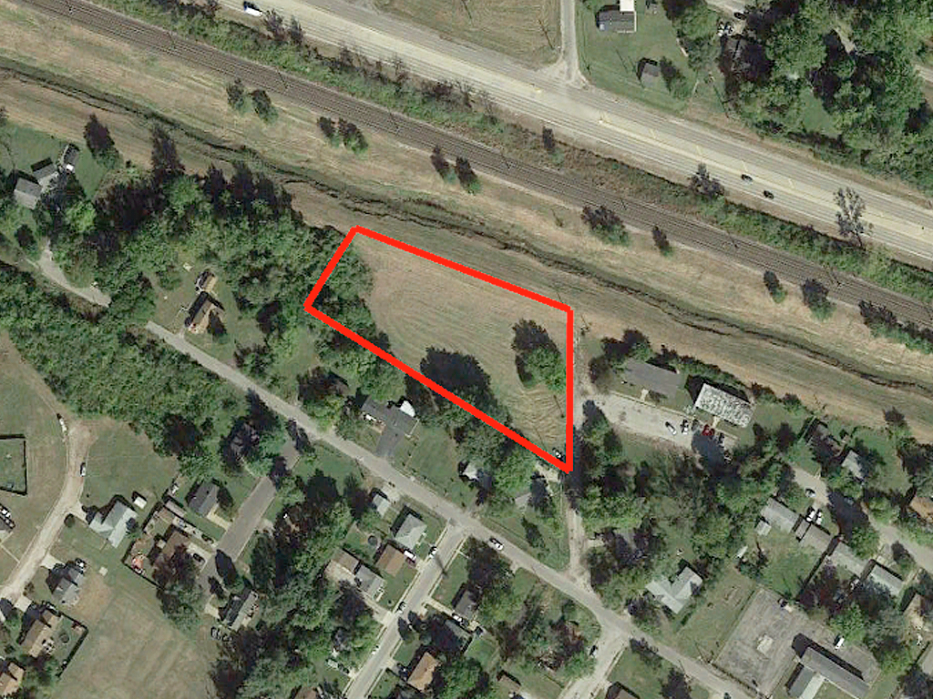
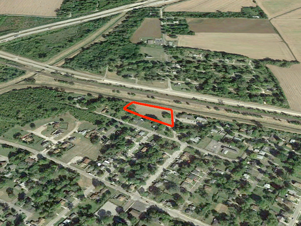
1.70 acres | Residential Zoning
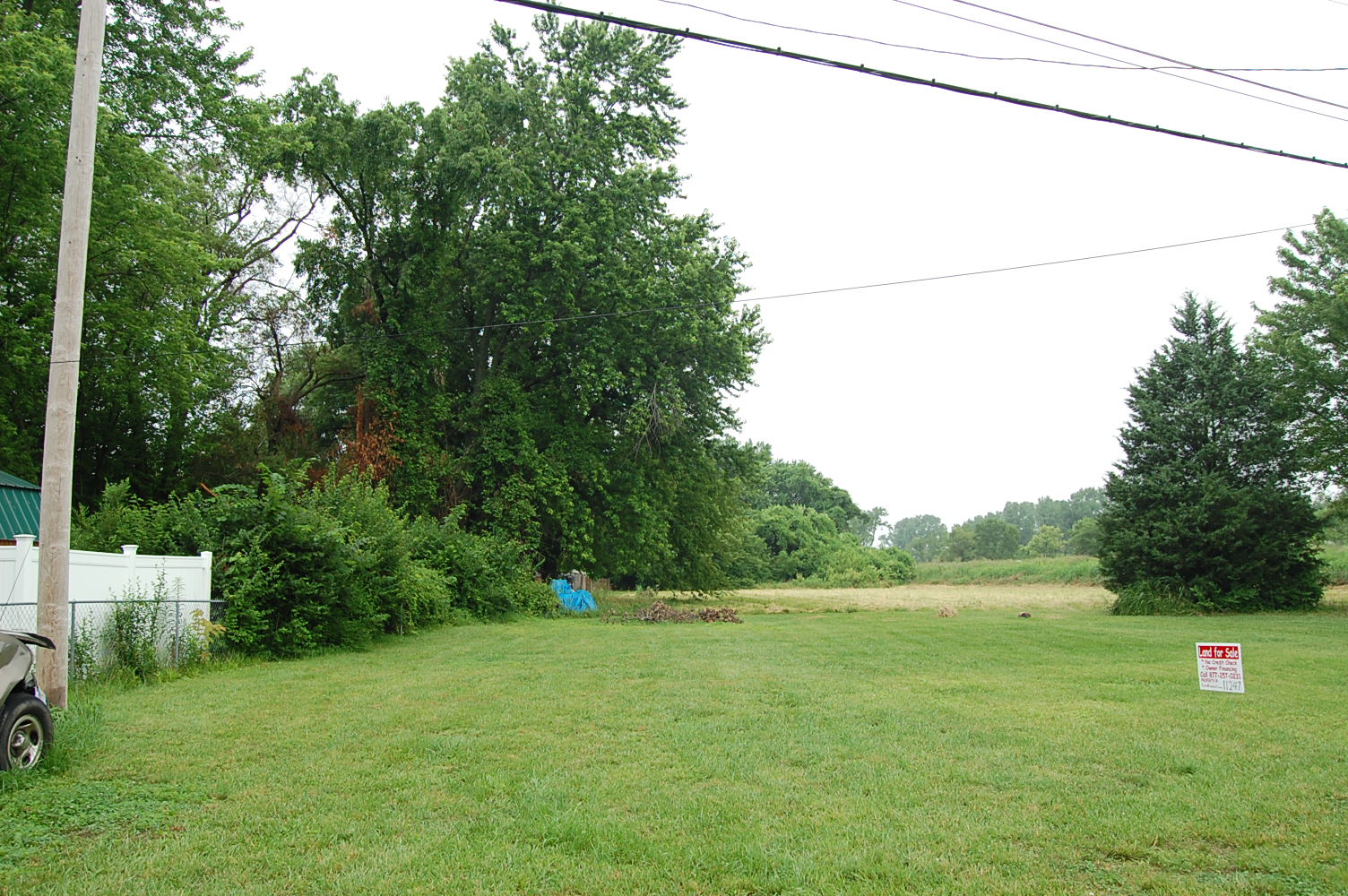
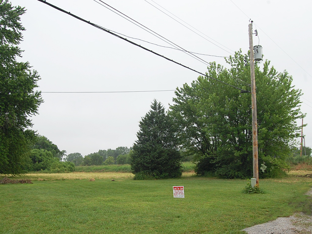
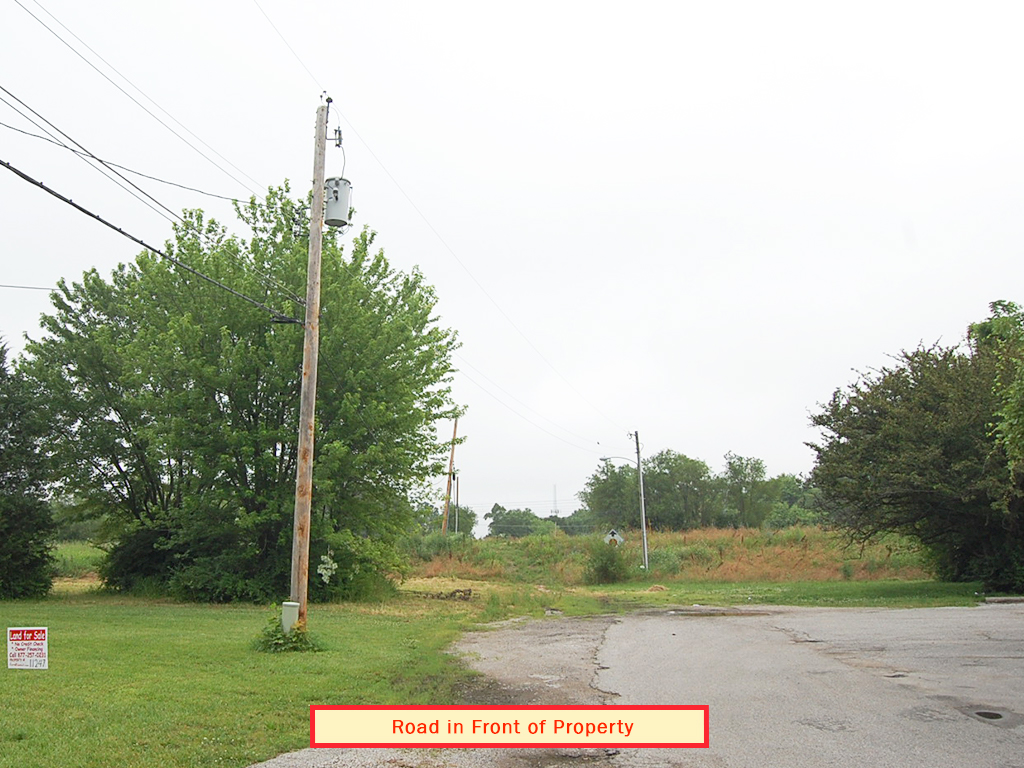
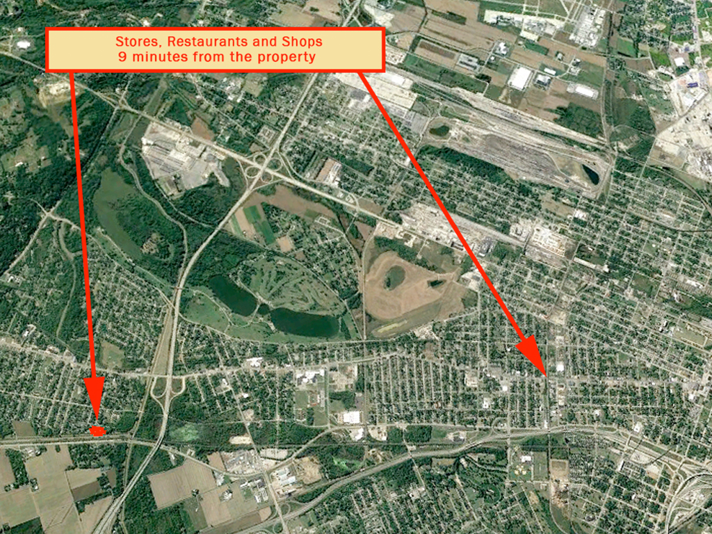
This rare 3 lot property is ready for your forever home. Located in the bustling area between Centreville and Fairview Heights, this 1.7 acre parcel is prime real estate close to every amenity imaginable. The ideal location for families looking to settle down, investors looking to increase their portfolio, or retirees ready to live the good life. The lot boasts several trees, power already available, a paved road leading in, and rests just along Schoenberger Creek. This size lot in this area won’t last long. Don’t wait!
Land Specifics Foreclosed
| Property Number | 11247 |
|---|---|
| Size | 1.70 acres |
| Dimensions | 350.79' x 245.10' x 475' x 142.92' |
| Road Access | Paved Road |
| Slope Description | Mostly Flat |
| Zoning | Residential |
| Zoning Code | R-2 (Two-Family Residential) |
| Zoning Definition |
R-2 (Two-Family Residential): The following regulations apply to R-2 two-family residential districts in the city: (1)Principal permitted uses: A.Any use permitted in the R-1A district, under the same conditions prescribed in such district. B.Two-family dwellings. (2)Accessory uses: A.Any accessory use or structure permitted in the R-1 district, under the same conditions prescribed in such district. B.Other accessory uses and structures customarily appurtenant to a principal permitted use. (3)Special uses: A.Any special use permitted in the R-1A district, under the same conditions prescribed in such district. B.Health centers. C.Licensed nursing homes. D.Social halls, lodges, fraternal organizations and clubs, except when operated for profit. E.Residential large-scale developments. (4)Height (maximum): A.Principal building: 2½ stories, but no more than 35 feet. B.Accessory building: 1½ stories, but no more than 15 feet. (5)Lot area per dwelling unit (minimum): 3,000 square feet. (6)Lot frontage (minimum): 60 feet. (7)Lot depth (minimum): 100 feet. (8)Yards (minimum): A.Front yard: 25 feet. B.Side yard: Five feet for each side. C.Rear yard: 20 feet. (9)Building coverage (maximum): A.Principal building: 30 percent. B.Accessory building: Ten percent. |
| On Property Usage/Potential |
|
| Nearby Usage |
|
Location
| County | St. Clair |
|---|---|
| State | Illinois |
| Other Maps |
|---|
Additional Information
| Assessor Parcel Number (APN) | 02 22.0 412 018 AND 02 22.0 412 012 AND 02 22.0 412 015 |
|---|---|
| Estimated Annual Taxes | $1052.60 |
| Legal Description |
That part of the Southeast Quarter of Section Numbered Twenty-two in Township Two North, Range Nine West of the Third Principal Meridian, more particularly described as follows, Commencing the survey thereof at the point that marks the intersection of the East line of said Section Numbered Twenty-two with the Northeasterly line of US Survey No. 725; running thence North 65 degrees 10 minutes West along the Northeasterly line of U5. Survey No. 725, a distance of Two Hundred Fifty—four and seven tenths feet to a point; running thence North 24 degrees 50 minutes East, a distance of One Hundred and Fifty-Five feet to the pipe which marks the point of beginning of the tract of land hereby intended to be conveyed; running thence North 24 degrees 50 minutes East, a distance of Eighty feet to a pipe; running thence South 65 degrees 0 minutes East, a distance of Eighty-three and six tenths feet to a pipe set in the West line of North 71st Street (being thirty feet in width and lying Fifteen feet on each side of the East line of Section 22); running thence South 8 degrees 13 minutes East, along a line lying parallel to the East line of said Section numbered Twenty-two a distance of Ninety five and Fifty-four hundredths feet to a pipe; running thence North 65 degrees 10 minutes West, a distance of One Hundred .and Thirty-five and eight tenths feet to the point of beginning; and That part of the Southeast Quarter of Section 22, Township 2 North, Range 9 West of the Third Principal Meridian, further described as follows: Commencing at the point that marks the intersection of the East fine of said Section 22 with the Northeasterly line of U. S. Survey T25, running thence North 65 degrees 10 minutes West along the Northeasterly line of U. S. Survey 725 a distance of 254.7 feet to a point; running thence North 24 degrees 50 minutes East a distance of 235 feet to the point of beginning of the tract to be described: Thence continuing North 24 degrees 50 minutes East a distance of 41.91 feet to a point; thence South 65 degrees 10 minutes East a distance of 56.33 feet to a point in the West line of North 71st Street, said Street being 30 feet in width and lying 15 feet on each side of the East line of said Section 22; thence South 8 degrees 13 minutes East a distance of 50 feet, along a line lying parallel to the East line of said Section 22, to a point; thence running North 65 degrees 10 minutes West a distance of 33.60 feet to the point of beginning, and That part of the Southeast 1/2 of Section 22, Township 2 North, Range 9 West 3 P.M, St. Clair County , Illinois, described as follows: Commencing at a point on the Northeasterly line of U.S. Survey No. 725 that is North 65°10’ West, a distance of 587.65 feet from the point that marks the intersection of the East line of Section 22, Township 2 North, Range 9 West 3 P.M., with the Northeasterly line of U.S. Survey No. 725; thence North 24°50’; East, a distance of 279.6 feet to the point of beginning of the tract of land herein described, said point being on the Southwesterly right of way line of a tract of land conveyed to the Commissioners of Drainage District No. 1 by Deed recorded in the Recorder's Office of St. Clair County, Illinois, in Book of Deeds 380 on Page 369; thence South 24°50‘ West, a distance of 124.6 feet to an iron rod; thence South 65°10‘ East, along a line lying parallel to the Northeasterly line of U.S. Survey No. 725, a distance of 332.95 feet to a pipe; thence North 24°50‘ East, a distance of 80.0 feet to a pipe; thence South 65° 10' East, a distance of 83.6 feet to a pipe set on the West line of North 71st Street, (being 30 feet in Width and lying 19.0 feet on—each side of the East line of Section 22; thence North 8°13‘ West, along a line to lying parallel and being 15.0 feet from the East line of Section 22, measured at a right angle) a distance of 141.2 feet to the Southwesterly right of way line of Drainage District No. 1; thence South 11°50‘ West, along the Southwesterly right of way line of Drainage District No. 1, a distance of 348.0 feet more or less to the point of beginning. Containing 1.35 acres or less. Subject to any easements of record in the aforesaid Recorder's Office affecting said land. Situated in the County of Saint Clair and State of Illinois. |
| Monthly HOA Dues | $0 |
| HOA | |
| HOA Dues | $0 |
| HOA Info |
This property has been sold.
This property is no longer available.
Use My LandCentral to be notified when a similar property is available in the future.
Or search available properties now:
Search Properties